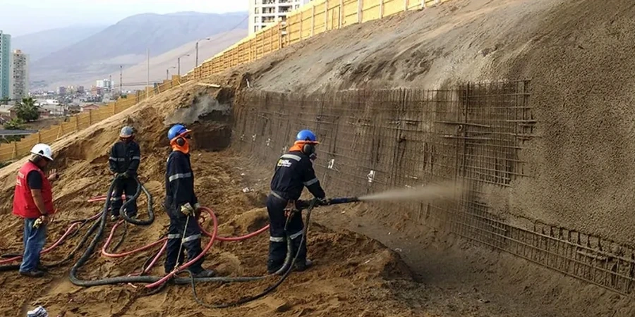
A Leica TS16 total station tracks 12 monitoring prisms along a failing cut in the Durie Hill loess. Three boreholes are logged 25 metres deep, recovering intact Shelby tube samples from the underlying papa mudstone. Whanganui sits on a staircase of uplifted marine terraces, capped by windblown loess that slakes on contact with water. The city’s 48,000 residents live among dissected hill country where 15° to 35° slopes are the norm, not the exception.
Our analysis starts with laboratory shear strength testing—direct shear and ring shear on the loess, triaxial on the papa—to feed a limit equilibrium model in Slide2. Pore pressure response to Whanganui’s 920 mm annual rainfall drives the phreatic surface we calibrate from vibrating wire piezometers. Before the first earthworks begin, we also run a CPT test to map continuous stratigraphy where access allows, or a MASW survey to image the shear wave velocity profile across the terrace scarps.
Whanganui loess loses 80 percent of its effective cohesion upon saturation—our limit equilibrium models capture this transition explicitly.
Local geotechnical context
The NZGS guidelines on landslide risk management classify Whanganui’s loess-mantled slopes as requiring a Level 2 quantitative assessment where the annual probability of failure exceeds 10⁻⁴. This threshold is easily crossed when fill is placed on the terrace edge without keying into the papa. The 2015 Whanganui flooding triggered over 300 shallow landslides across the city’s eastern suburbs—a wake-up call for developers who previously relied on empirical setback distances alone.
A deterministic factor of safety below 1.2 does not tell the full story; we therefore run Monte Carlo simulations with 10,000 trials to express failure probability as a function of effective friction angle variability. The resulting hazard curve, combined with a consequence class from NZS 3404, determines whether the slope requires drainage, retaining structures, or regrading. Ignoring the loess-papa interface friction—which can degrade to just 18° when polished by shearing—is the single most common cause of under-designed slopes in this region.
Quick answers
What triggers most slope failures in Whanganui?
Rainfall infiltration into the loess mantle is the primary trigger. Whanganui’s 920 mm annual rainfall, concentrated in winter storms, saturates the upper 2–3 metres of loess, destroying apparent cohesion and raising pore pressure at the loess-papa contact. Prolonged wet periods are far more dangerous than single intense events.
How is seismic slope stability handled for Whanganui sites?
We apply a horizontal seismic coefficient (kₕ) between 0.15 and 0.25, derived from NZS 1170.5:2004 site subsoil classification. Pseudo-static analysis is run in Slide2; for critical slopes near occupied buildings, we also perform Newmark displacement analysis to estimate permanent deformation during a 1-in-500-year event.
What factor of safety is required for a residential subdivision?
For permanent cuts in a residential subdivision, the NZGS guidelines and good practice in Whanganui require a minimum static factor of safety of 1.5. Temporary construction slopes may be designed to 1.3, provided they are monitored and not left exposed through a wet winter.
Do you drill boreholes for slope stability analysis?
Yes, we coordinate hollow-stem auger and rotary core drilling to depths of 15–35 metres, depending on the slope geometry. The boreholes recover undisturbed samples for laboratory shear testing and allow installation of standpipe or vibrating wire piezometers to establish the long-term groundwater profile.
What does a slope stability analysis cost in Whanganui?
The fee ranges from NZ$2,380 for a desktop review with existing data to NZ$8,020 for a full quantitative risk assessment that includes site investigation, laboratory testing, and limit equilibrium modelling. The final scope depends on the slope height, consequence class, and data availability.